


Panoply for Windows 7 - "Experience Data Visualization Like Never Before with Panoply" - Windows 7 Download

Panoply 5.9.2
"Transform complex data into stunning visualizations with Panoply - the ultimate Windows 7 software for data analysis."
Looking for a powerful tool to visualize and analyze scientific data? Look no further than Panoply from Robert B. Schmunk. This intuitive software allows users to quickly and easily create custom plots and maps, while also providing advanced analysis capabilities. With its user-friendly interface and wide range of features, Panoply is a must-have for researchers and scientists alike. Download now and start visualizing your data with ease!
Panoply 5.9.2 full details

| File Size: | 50.90 MB |
|---|---|
| License: | Freeware |
| Price: | FREE |
| Released: |
2026-03-29
 |
| Downloads: | Total: 725 | This Month: 214 |
| Publisher: | Robert B. Schmunk |
| Publisher URL: | https://www.giss.nasa.gov/ |

Download Panoply 5.9.2
Save Panoply to My Stuff
Tweet
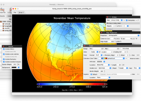
Panoply 5.9.2 full screenshots


Panoply - Windows 7 Download awards


Panoply 5.9.2 full description
Panoply is a cross-platform application which plots geo-gridded arrays from netCDF, HDF and GRIB datasets. Panoply is a cross-platform software application whose purpose is to help you plot raster images. It lets you view photos created with NetCDF, HDF, GEMPACK, GRIB and other datasets, and combine or slice geo-gridded and other types of arrays. Files can be imported in the working environment using the built-in browse button or drag-and-drop support. You are allowed to add data from one of the datasets mentioned at the beginning of the review and print or export plots to KMZ, GIF, PDF, PNG, PS, AVI or MOV file format. In addition, you may save data to CSV, CDL or plain text file format.
Panoply is a noteworthy and comprehensive software application that helps you plot and analyze raster images of geo-gridded data from NetCDF and other datasets. The GUI cannot be described as highly intuitive so rookies may need extra time to get used to working with it.
You can:
* Slice and plot specific latitude-longitude, latitude-vertical, or time-latitude arrays from larger multidimensional variables.
* Combine two arrays in one plot by differencing, summing or averaging.
* Plot lon-lat data on a global or regional map (using any of over 75 map projections) or make a zonal average lineplot.
* Overlay continent outlines or masks on lon-lat plots.
* Use any ACT, CPT, GGR, or PAL color table for scale colorbar.
* Save plots to disk GIF, JPEG, PNG or TIFF bitmap images or as PDF or PostScript graphics files.
* Export lon-lat map plots in KMZ format.
Panoply 5.9.2 download tags
Panoply 5.9.2 Windows 7 release notes
New Release
Refactored colorbar library management to remove redundant and unused code.
Added favorites checkbox to colorbar browser.
Bugfix: UTM gridder rejected some data due to incorrect name attribute test.
Updated CPT color table file parser to understand updated file format.
Library: Updated netCDF-Java to v. 5.10.0 (snapshot 3/16).
[ Panoply release history ]
Bookmark Panoply
Panoply for Windows 7 - Copyright information
All Panoply reviews, submitted ratings and written comments become the sole property of Windows 7 download. You acknowledge that you, not windows7download, are responsible for the contents of your submission. However, windows7download reserves the right to remove or refuse to post any submission for any reason.
Windows 7 Download periodically updates pricing and software information of Panoply full version from the publisher, but some information may be out-of-date. You should confirm all information.
Using warez version, crack, warez passwords, patches, serial numbers, registration codes, key generator, pirate key, keymaker or keygen for Panoply license key is illegal and prevent future development of Panoply. Download links are directly from our mirrors or publisher's website, Panoply torrent or shared files from free file sharing and free upload services, including Rapidshare, MegaUpload, YouSendIt, SendSpace, DepositFiles, DivShare, HellShare, HotFile, FileServe or MediaFire, are not used.
Post Panoply review


Windows 7 Panoply related downloads
Discover the power of data visualization and analysis with TOPCAT Full, an exceptional software ... for OPerations on Catalogues And Tables) is a versatile tool that allows users to manipulate and visualize ...
... elevate your calculation experience on Windows 7. This versatile tool goes beyond basic arithmetic, offering a comprehensive ...
... talented gnuplot Team.
Gnuplot is a powerful and versatile plotting software that allows users to visualize and ...
Discover the power of precision with Portable QCAD Professional, the ultimate CAD software designed for Windows ...
DAZ Studio 4 Genesis™ Figure Platform wins the 3D World CG Technology Award. The Genesis Figure ...
My Account
Help
Windows 7 Software Coupons
-
MacX MediaTrans
63% Off -
WinX DVD Copy Pro
42% Off -
MacX Video Converter Pro
56% Off -
MacX DVD Ripper Pro
50% Off -
MacX DVD Video Converter
58% Off
My Saved Stuff
You have not saved any software.
Click "Save" next to each software.
Click "Save" next to each software.
Would you like to receive announcements of new versions of your software by email or by RSS reader? Register for FREE!
Windows 7 Downloads Picks
- GeoGebra 6.0.920.0
- VariCAD Viewer 2026 1.01
- VariCad 2026 1.01
- IP Video System Design Tool 2026.0.1.2455
- Windows Live Essentials 2011
- Windows Live Essentials 2012 16.4.3528
- ProsimGraphsPro 11.0
- FET 7.8.5
- Portable Balabolka 2.15.0.915
- DAZ Studio 4.24.0.4
- Mindomo Desktop 11.1.8.0
- Google Earth 7.3.6.10155
- Panoply 5.9.2
- Metes and Bounds 6.4.6
- WinStitch 2024.5.6
- Gephi 0.11.1
- Bible Analyzer 5.6.5
- WinStars 3.0.305 (2026
- Tux Paint 0.9.33
- EarMaster Pro 7.8.90
Popular Tags
forecast
software
organizer
baseball
email
forum
punter
racing
mlb
ebook
gambling
collection
soccer
postsmile
betting
bet
tips
premier
masterra
betfair
home
handicapping
sport
football
basketball
nfl
prediction
picks
league
inventory
Popular Windows 7 Software
- GeoGebra 6.0.920.0
- VariCAD Viewer 2026 1.01
- VariCad 2026 1.01
- IP Video System Design Tool 2026.0.1.2455
- PowerBK Book Organizer Software 4.2.8
- NetLogo 7.0.4
- Windows Live Essentials 2011
- Windows Live Essentials 2012 16.4.3528
- ProsimGraphsPro 11.0
- Lottery Number Generator Software 7.0
- FET 7.8.5
- Portable Balabolka 2.15.0.915
- Free Kundli Software 1.2.0.1
- Free Tamil Astrology Software 1.2.0.1
- Cutting Optimization Pro 5.18.21.4
© 2026 Windows7Download.com - All logos, trademarks, art and other creative works are and remain copyright and property of their respective owners. Microsoft Windows is a registered trademarks of Microsoft Corporation. Microsoft Corporation in no way endorses or is affiliated with windows7download.com.