


Metes and Bounds for Windows 7 - "Precision Mapping with Metes & Bounds" - Windows 7 Download

Metes and Bounds 6.4.4r1
"Precision mapping made easy. Unlock accurate property measurements with Metes and Bounds."
Looking for reliable and user-friendly software to create professional land surveys? Look no further than Metes and Bounds, the industry standard for surveying software. Designed by Sandyknoll Software, Metes and Bounds lets you easily calculate areas, perimeters, and more, with intuitive tools and customizable templates. Trust us, your surveying work will never be the same with this powerful and versatile tool!
Metes and Bounds 6.4.4r1 full details

| File Size: | 47.20 MB |
|---|---|
| License: | Demo |
| Price: | $39.95 |
| Released: |
2026-03-18
 |
| Downloads: | Total: 1387 | This Month: 157 |
| Publisher: | Sandy Knoll Software |
| Publisher URL: | http://www.tabberer.com/sandyknoll/more/3dmaker/anaglyph-software.html |

Download Metes and Bounds 6.4.4r1
Save Metes and Bounds to My Stuff
Tweet
Metes and Bounds - Windows 7 Download awards


Metes and Bounds 6.4.4r1 full description
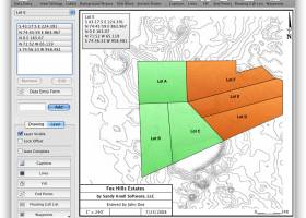
Metes and Bounds is a software that can create plot maps, perform calculations in square feets, acres, hectares, perimeter distance and more. Metes and Bounds turns data into a deed plot map. It can calculate square feet, acreage and hectares.
Enter measurements in rods, chains, meters, yards, inches, fathoms, hands, spans or furlongs. Angles can be given down to minutes and seconds. Can auto-close a plot drawing if the final plot segment is missing. Calculate area. Custom labels and backgrounds. Split single plots into multiple plots. GPS Waypoints and more.
The Drawing Wizard is an optional way to start a new drawing. It will ask you several questions about what type of drawing you plan on creating. Based on your answers to these questions, the wizard will preset some of the drawing values to help you accomplish your goals.
FEATURES:
· Perform calculations: Square Feet, Acres, Hectares, perimeter distance and more.
· Easy to use data entry form: Enter lines or curve data.
· Layers: Layers allow you to have multiple deeds on a single drawing. Layers can be free floating or locked to a common starting point.
· Metes & Bounds will calculate if the survey closes or not. Calculate closure errors.
· Auto-Completion of drawing. If you're missing the final segment of your land plotting data, let our Metes and Bounds land plotting software finish it for you. Have a bad or missing call? Enter a question mark (?) for the call and let the software find the missing call for you.
· Multiple measurement types: Data can be inputted using Feet, meters, rods, chains, varas and many other measurement types
· Easy to use measuring tool. Estimate the distance between any two points on the screen.
· Automatic labeling: Each line can be automatically labeled with the length and call. End points can be marked for easier recognition. End points can also be labeled with information like the interior and exterior angles.
Create custom labels and backgrounds. Labels can be rotated in 90 degree increments. Drawings can include a call list:
· Backgrounds can be set to scale with your plot drawing.
· Split a single plot into multiple plots. Split the plot by hand, or choose a starting point and let the Metes and Bounds software find the nearest halves automatically for you.
· Create section drawings.
· Exporting: Metes and Bounds data can be exported as a DXF file, KML File, CSV file and more.
· Printing: Printouts can include borders, call list, north arrow and title block.
· Real-world X,Y coordinates. Export real-world X,Y coordinates for integration with other mapping software such as GIS software.
· Custom X,Y points. Use custom X,Y points to mark and label unique land features on the metes and bounds drawing.
· Real-world Latitude and Longitude coordinates. Enter the latitude and longitude for a plot's POB and let the metes and bounds software calculate the latitude and longitude for each of the other end points.
· Waypoints to metes and bounds calls. Convert a set of waypoints, x/y or Latitude/Longitude based, into a list of metes and bounds calls.
· Enter Waypoints and Tracks. Add GPS waypoints and tracks to your drawings. Import GPX and KML files. Make calculations like the distance between two waypoints.
Metes and Bounds 6.4.4r1 download tags
Metes and Bounds 6.4.4r1 Windows 7 release notes
Bookmark Metes and Bounds
Metes and Bounds for Windows 7 - Copyright information
All Metes and Bounds reviews, submitted ratings and written comments become the sole property of Windows 7 download. You acknowledge that you, not windows7download, are responsible for the contents of your submission. However, windows7download reserves the right to remove or refuse to post any submission for any reason.
Windows 7 Download periodically updates pricing and software information of Metes and Bounds full version from the publisher, but some information may be out-of-date. You should confirm all information.
Using warez version, crack, warez passwords, patches, serial numbers, registration codes, key generator, pirate key, keymaker or keygen for Metes and Bounds license key is illegal and prevent future development of Metes and Bounds. Download links are directly from our mirrors or publisher's website, Metes and Bounds torrent or shared files from free file sharing and free upload services, including Rapidshare, MegaUpload, YouSendIt, SendSpace, DepositFiles, DivShare, HellShare, HotFile, FileServe or MediaFire, are not used.
Post Metes and Bounds review


Windows 7 Metes and Bounds related downloads
Alternate Calculator is a simple application for calculations that contains ... anyone dealing with multiple types of money. Alternate Calculator features all the standard functions one would expect ...
... on your next gas purchase? The Gas Price Calculator will give you the answer. Just enter the ...
Introducing the Softball/Baseball Team Calculator, the ultimate tool for coaches, players, and team managers looking to streamline their game strategy ...
... electronic projects? Look no further! Introducing the Resistor Calculator, a must-have software developed by AB-Tools.com GmbH. This ...
Discover the power of mathematics with Graphing Calculator 3D, an innovative software developed by Runiter, designed ...
My Account
Help
Windows 7 Software Coupons
-
WinX DVD Copy Pro
42% Off -
MacX Video Converter Pro
56% Off -
MacX MediaTrans
63% Off -
Media Player Morpher
85% Off -
FREE VPN PROXY by SEED4.ME WINDOWS
Free VPN by Seed4Me
My Saved Stuff
You have not saved any software.
Click "Save" next to each software.
Click "Save" next to each software.
Would you like to receive announcements of new versions of your software by email or by RSS reader? Register for FREE!
Windows 7 Downloads Picks
- GeoGebra 6.0.920.0
- VariCAD Viewer 2026 1.01
- VariCad 2026 1.01
- IP Video System Design Tool 2025.2.0.2402
- Windows Live Essentials 2011
- Windows Live Essentials 2012 16.4.3528
- ProsimGraphsPro 11.0
- FET 7.8.0
- Portable Balabolka 2.15.0.913
- DAZ Studio 4.24.0.4
- Mindomo Desktop 11.1.5.0
- Google Earth 7.3.6.10155
- Panoply 5.9.1
- WinStitch 2024.5.6
- Bible Analyzer 5.6.5
- Tux Paint 0.9.33
- EarMaster Pro 7.8.90
- Metes and Bounds 6.4.4r1
- Gnuplot for Mac OS X 6.0.1
- WinStars 3.0.304 (2025
Popular Tags
collection
punter
forum
email
bet
gambling
football
prediction
inventory
ebook
baseball
mlb
tips
nfl
betfair
handicapping
organizer
basketball
postsmile
forecast
league
picks
masterra
betting
sport
racing
premier
home
software
soccer
Popular Windows 7 Software
- GeoGebra 6.0.920.0
- VariCAD Viewer 2026 1.01
- VariCad 2026 1.01
- IP Video System Design Tool 2025.2.0.2402
- PowerBK Book Organizer Software 4.2.8
- Windows Live Essentials 2011
- Windows Live Essentials 2012 16.4.3528
- Offline Map Maker 8.378
- ProsimGraphsPro 11.0
- Lottery Number Generator Software 7.0
- FET 7.8.0
- Portable Balabolka 2.15.0.913
- Free Tamil Astrology Software 1.2.0.1
- Free Kundli Software 1.2.0.1
- NetLogo 7.0.2
© 2026 Windows7Download.com - All logos, trademarks, art and other creative works are and remain copyright and property of their respective owners. Microsoft Windows is a registered trademarks of Microsoft Corporation. Microsoft Corporation in no way endorses or is affiliated with windows7download.com.