


MountainsMap Scanning Topography for Windows 7 - High-precision topography software. - Windows 7 Download

MountainsMap Scanning Topography 6.2.6266
"Explore new heights with MountainsMap Scanning Topography - the ultimate 3D analysis software for Windows 7."
Looking for a topographic mapping software that provides accurate and reliable data? Look no further than MountainsMap Scanning Topography by Digital Surf. With its sophisticated algorithms, this tool offers unparalleled precision when it comes to measuring surface topography. Plus, its user-friendly interface makes it accessible for both novice and experienced users. Whether you're a scientist, engineer or industrial designer, MountainsMap Scanning Topography is an essential software in your toolkit. Get your hands on it today and discover how it can help streamline your workflow and increase your productivity.
MountainsMap Scanning Topography 6.2.6266 full details

| File Size: | 511.00 MB |
|---|---|
| License: | Trialware |
| Price: | FREE |
| Released: | 2014-09-29 |
| Downloads: | Total: 603 | This Month: 144 |
| Publisher: | Digital Surf |
| Publisher URL: | http://www.digitalsurf.fr/en/mntscantopo.html |

Download MountainsMap Scanning Topography 6.2.6266
Save MountainsMap Scanning Topography to My Stuff
Tweet
MountainsMap Scanning Topography - Windows 7 Download awards

MountainsMap Scanning Topography 6.2.6266 full description
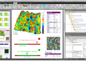
MountainsMap Scanning Topography is a professional application designed to perform surface analysis for 3D surface profilometers.
With MountainsMap Scanning Topography, users will be able to easily analyze measurements and metrology data. It features an extensive set of surface texture parameters.
FEATURES:
MountainsMap® Scanning Topography is the best in class surface analysis solution for profilometers
Entry level solution with a wide range of incremental optional modules for advanced applications.
Analyzes measurement data in accordance with the latest standards and methods.
Straightforward upgrade path to MountainsMap® Universal if you add a new type of instrument to your instrument park.
Real time high quality 3D imaging
View 3D surface topography in 24-bit colors, manipulate it in real time, apply different renderings and palettes, make movies of surface flyovers, etc.
Clean up measurement data using powerful filters to remove anomalies, correct scan lines, etc. and use morphological filtering or tip deconvolution to minimize stylus or spot shape impact.
Increase vertical range virtually
Increase vertical range by manually patching together overlapping measurements on the vertical axis.
The most popular 2D and 3D surface texture parameters
Calculate 3D height and bearing ratio parameters defined in the new ISO 25178 standard and EUR 15178 (Surfstand), ISO 4287 2D primary and roughness parameters, BSI, DIN, JIS, NF, UNE and UNI equivalents of ISO parameters, together with and ASME B46.1 3D parameters.
Basic analysis of surface texture and geometry
Calculation of distances, angles, areas, volumes and step heights.
3D surface roughness analysis based on ISO 16610 advanced filtering techniques.
Basic functional studies including bearing ratio curve, depth distribution histogram, surface subtraction and more.
Analyze sub-surfaces too
Use segmentation or thresholding to extract a sub-surface – for example a disk fixture ring, contact zone, MEMS layer or valley region - and analyze it independently, calculating parameters (e.g. flatness) for the sub-surface only.
Fast surface metrology report creation
The highly intuitive desktop publishing environment (in seven European languages, Japanese, Mandarin Chinese and Korean) includes a page viewer for fast navigation, an analysis workflow for full metrological traceability and pass/fail traffic lights.
Series of measurements can be analyzed automatically using templates and common sequences of analysis steps can be saved in a library for insertion in future reports.
Data export (Excel .csv, text, bitmap, PDF).
MountainsMap Scanning Topography 6.2.6266 download tags
MountainsMap Scanning Topography 6.2.6266 Windows 7 release notes
New Release
Surface partitioning with or without leveling:
· A sub-surface can be extracted with or without leveling using the Partition Leveling operator.
Contour Analysis/Advanced Contour Analysis module enhancements:
· Horizontal contour extraction with smoothing - parametric profiles extracted on the XY plane can be smoothed automatically.
Integration of Chinese GB/T standards:
· The quot;right parameters wherever you arequot; feature has been extended to include Chinese GB/T standard references for parameter families, which can be selected in Metrological Preferences - References.
Advanced Contour Analysis module enhancements:
· Automatic association of geometric elements with profiles - line segments, arcs and circles (greater than a specified minimum size) can be automatically associated with profiles. This significantly speeds up the definition of nominal form (which is otherwise carried out interactively or by fitting CAD DXF data to the profile).
[ MountainsMap Scanning Topography release history ]
Bookmark MountainsMap Scanning Topography
MountainsMap Scanning Topography for Windows 7 - Copyright information
All MountainsMap Scanning Topography reviews, submitted ratings and written comments become the sole property of Windows 7 download. You acknowledge that you, not windows7download, are responsible for the contents of your submission. However, windows7download reserves the right to remove or refuse to post any submission for any reason.
Windows 7 Download periodically updates pricing and software information of MountainsMap Scanning Topography full version from the publisher, but some information may be out-of-date. You should confirm all information.
Using warez version, crack, warez passwords, patches, serial numbers, registration codes, key generator, pirate key, keymaker or keygen for MountainsMap Scanning Topography license key is illegal and prevent future development of MountainsMap Scanning Topography. Download links are directly from our mirrors or publisher's website, MountainsMap Scanning Topography torrent or shared files from free file sharing and free upload services, including Rapidshare, MegaUpload, YouSendIt, SendSpace, DepositFiles, DivShare, HellShare, HotFile, FileServe or MediaFire, are not used.
Post MountainsMap Scanning Topography review


Windows 7 MountainsMap Scanning Topography related downloads
TriSpace is a powerful and user-friendly software developed by GEOSTRU for Windows 7 that is designed ...
... Windows 7 users. TriSpace revolutionizes the field of topography with its advanced features and user-friendly interface. Seamlessly ...
... transforms a regular PC into a powerful caliper measurement tool, providing accurate, fast and reliable results. With ...
Are you in need of an advanced process control system for your industrial applications? Look no ...
... and robust functionality, you'll be exploring the world's surface in no time. Download now to unlock a ...
My Account
Help
Windows 7 Software Coupons
-
WinX HD Video Converter
56% Off -
MacX MediaTrans
63% Off -
WinX DVD Ripper
50% Off -
WinX MediaTrans
63% Off -
MacX Video Converter Pro
56% Off
My Saved Stuff
You have not saved any software.
Click "Save" next to each software.
Click "Save" next to each software.
Would you like to receive announcements of new versions of your software by email or by RSS reader? Register for FREE!
Windows 7 Downloads Picks
- LochMaster 4.0
- BricsCad Classic 24.2.06-1
- Sweet Home 3D 7.4
- Mobile Atlas Creator 2.2.1
- MVSP 3.22
- MaxIm DL 6.05
- Graph Streaming 0.7.0.12
- GPS Utility 5.51
- Melanie Viewer 7.0.7
- Geneious PRO x64 6.0.4
- Sprint-Layout 6.0
- DICOMscope 3.5.1
- Geneious PRO for Vista 4.7.6
- Jmol 14.31.53
- LabCollector 4.96
- EAGLE Light 9.6.2
- Geneious PRO 6.0.4
- CurveExpert Professional 2.7.3
- Gephi 0.10.1
- Circuit Diagram 3.1.0 B3
Popular Tags
assembly
cad
dwg
stl
dxf
open
obj file
converter
solidedge
view
landscape
export
stl file
software
hpgl
intellicad
plug in
convert
animation
architect
import
viewer
cam
home
design
bmp
solidworks
file
dwg viewer
autocad
Popular Windows 7 Software
- CorelDRAW X7 (x32 bit) 17.4.0.887
- CorelDRAW X7 (x64 bit) 17.4.0.887
- CorelDRAW X5 15.2.0.686
- CorelDRAW X4
- iTop Screenshot 1.2.3.544
- CorelDRAW 2017 19.1.0.419
- CorelDRAW X6 16.4.0.1280
- Blender - 32 bit 2.80
- Adobe InDesign CS5 CS5.5 7.5.3
- CorelDRAW X8 18.0.0.450
- Graphic Workshop Professional 15.0a rev11
- Model Air Design 2.4
- Blender Portable 4.1.1
- Paint.NET 5.0.13
- Model Air Design 2.4
© 2026 Windows7Download.com - All logos, trademarks, art and other creative works are and remain copyright and property of their respective owners. Microsoft Windows is a registered trademarks of Microsoft Corporation. Microsoft Corporation in no way endorses or is affiliated with windows7download.com.