


GEOPoint for Windows 7 - GEOPoint: Ultimate Geocaching Tool. - Windows 7 Download

GEOPoint 5.1
Review: Discover locations with GEOPoint - Efficient & user-friendly Windows 7 software.
Looking for a reliable and robust mapping software that meets all your needs? Check out GEOPoint by Gunamoi Software. With easy-to-use interfaces and innovative features like GPS integration, topo maps, and elevation profiles, this Windows 7 software is perfect for outdoor enthusiasts, explorers, and professionals. Download now and start exploring the world around you like never before.
GEOPoint 5.1 full details

| File Size: | 20.40 MB |
|---|---|
| License: | Demo |
| Price: | $50.00 |
| Released: | 2024-06-22 |
| Downloads: | Total: 736 | This Month: 248 |
| Publisher: | Gunamoi Software |
| Publisher URL: | https://gunamoi.com.au/ |

Download GEOPoint 5.1
Save GEOPoint to My Stuff
Tweet
GEOPoint 5.1 full screenshots
GEOPoint - Windows 7 Download awards


GEOPoint 5.1 full description
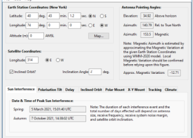
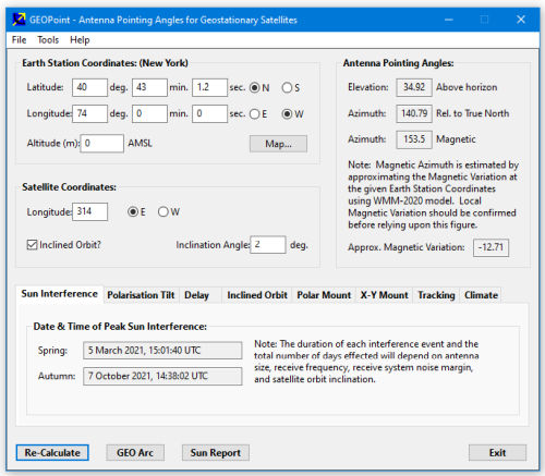
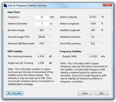
GEOPoint is an easy to use satellite antenna pointing calculator, for geostationary communications satellites. It calculates the azimuth and elevation pointing angles from a given location on the earth towards a specified geostationary satellite. The program also calculates polarisation tilt angles, estimates dates and times of annual sun-outage events, calculates antenna G/T, EIRP and frequency stability, and estimates path-loss and rain-attenuation based on ITU-R climate models. As used by Hausfeld Consulting for satellite communications planning.
Anyone may download and install GEOPoint to access the basic Lite features free of charge.
Lite Features (Free):
an easy to use dialog-style user interface for data entry and calculation;
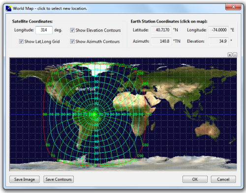
entry of earth station location coordinates directly, or by clicking on a world map;
select earth station location from a built-in list of world major cities;
display of satellite azimuth and elevation contours on the world map to aid in site selection;
entry of latitude and longitude coordinates in d,m,s format, or as decimal degrees;
entry of coordinates in Australian AMG coordinates and automatic conversion to latitude, longitude;
calculation of pointing angles to a specified satellite for common types of antenna mount;
display of azimuth pointing angles relative to True North, and relative to local magnetic north;
estimation of antenna movement limits for inclined orbit satellites;
calculation of polarisation tilt angle, loop-back path delay, and required antenna tracking speeds;
estimation of the peak dates and times for sun-interference on the receive link.
Output of a summary report in PDF or HTML format.
Pro Features (requires Registration):
ability to zoom the world map one level for more accurate site selection;
ability to save the current map image to file.
ability to save azimuth and elevation contours to a KML file for viewing in Google Earth.
estimation of site altitude from ITU-R world topography model;
select earth station location from a user supplied file containing a list of sites;
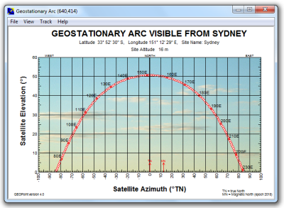
view and save a diagram of the GEO Arc visible from the site;
labelling of individual satellites and plotting local horizon and antenna movement limits;
plotting of satellite locations from Norad two-line element or Intelsat ephemeris format orbit data;
display of ITU-R Climate Model data for the specified earth station location;
estimate antenna G/T from user inputs of antenna parameters and frequency;
calculate path loss between the earth station and satellite at a specified frequency using ITU-R propagation models;
estimate the impact of satellite motion on EIRP and frequency stability;
output a batch report of pointing angles from the site, for a list of user selected satellites;
output a detailed report of sun interference dates and times for given receive antenna parameters;
output a detailed report of rain attenuation loss for a range of frequencies and link availability;
output a batch summary report for a list of earth station sites.
Anyone may download and install GEOPoint to access the basic Lite features free of charge.
Lite Features (Free):
an easy to use dialog-style user interface for data entry and calculation;
entry of earth station location coordinates directly, or by clicking on a world map;
select earth station location from a built-in list of world major cities;
display of satellite azimuth and elevation contours on the world map to aid in site selection;
entry of latitude and longitude coordinates in d,m,s format, or as decimal degrees;
entry of coordinates in Australian AMG coordinates and automatic conversion to latitude, longitude;
calculation of pointing angles to a specified satellite for common types of antenna mount;
display of azimuth pointing angles relative to True North, and relative to local magnetic north;
estimation of antenna movement limits for inclined orbit satellites;
calculation of polarisation tilt angle, loop-back path delay, and required antenna tracking speeds;
estimation of the peak dates and times for sun-interference on the receive link.
Output of a summary report in PDF or HTML format.
Pro Features (requires Registration):
ability to zoom the world map one level for more accurate site selection;
ability to save the current map image to file.
ability to save azimuth and elevation contours to a KML file for viewing in Google Earth.
estimation of site altitude from ITU-R world topography model;
select earth station location from a user supplied file containing a list of sites;
view and save a diagram of the GEO Arc visible from the site;
labelling of individual satellites and plotting local horizon and antenna movement limits;
plotting of satellite locations from Norad two-line element or Intelsat ephemeris format orbit data;
display of ITU-R Climate Model data for the specified earth station location;
estimate antenna G/T from user inputs of antenna parameters and frequency;
calculate path loss between the earth station and satellite at a specified frequency using ITU-R propagation models;
estimate the impact of satellite motion on EIRP and frequency stability;
output a batch report of pointing angles from the site, for a list of user selected satellites;
output a detailed report of sun interference dates and times for given receive antenna parameters;
output a detailed report of rain attenuation loss for a range of frequencies and link availability;
output a batch summary report for a list of earth station sites.
GEOPoint 5.1 download tags
Bookmark GEOPoint
GEOPoint for Windows 7 - Copyright information
All GEOPoint reviews, submitted ratings and written comments become the sole property of Windows 7 download. You acknowledge that you, not windows7download, are responsible for the contents of your submission. However, windows7download reserves the right to remove or refuse to post any submission for any reason.
Windows 7 Download periodically updates pricing and software information of GEOPoint full version from the publisher, but some information may be out-of-date. You should confirm all information.
Using warez version, crack, warez passwords, patches, serial numbers, registration codes, key generator, pirate key, keymaker or keygen for GEOPoint license key is illegal and prevent future development of GEOPoint. Download links are directly from our mirrors or publisher's website, GEOPoint torrent or shared files from free file sharing and free upload services, including Rapidshare, MegaUpload, YouSendIt, SendSpace, DepositFiles, DivShare, HellShare, HotFile, FileServe or MediaFire, are not used.
Post GEOPoint review


Windows 7 GEOPoint related downloads
The antenna calculator is a very simple and easy piece of software. This calculator provides quick estimation of antenna size ...
Introducing Model Air Design, the ultimate software developed by the renowned team at Model Air Design. This exceptional Windows 7-compatible application is a dream ...
Welcome to the ultimate destination for Windows 7 software downloads! We are proud to introduce Carlson Design ...
... to the ultimate destination for all your paving design needs - the Paving Design Expert software download ...
Welcome to our dedicated Windows 7 software download platform, where we present to you the innovative "Model Air Design" software, a masterpiece crafted by the renowned developer, ...
My Account
Help
Windows 7 Software Coupons
-
MacX MediaTrans
63% Off -
WinX DVD Copy Pro
42% Off -
MacX Media Management Bundle
70% Off -
MacX DVD Ripper Pro
50% Off -
WinX DVD Ripper
50% Off
My Saved Stuff
You have not saved any software.
Click "Save" next to each software.
Click "Save" next to each software.
Would you like to receive announcements of new versions of your software by email or by RSS reader? Register for FREE!
Windows 7 Downloads Picks
- LochMaster 4.0
- BricsCad Classic 24.2.06-1
- Sweet Home 3D 7.4
- Mobile Atlas Creator 2.2.1
- MVSP 3.22
- MaxIm DL 6.05
- Graph Streaming 0.7.0.12
- GPS Utility 5.51
- Melanie Viewer 7.0.7
- Geneious PRO x64 6.0.4
- Sprint-Layout 6.0
- DICOMscope 3.5.1
- Jmol 14.31.53
- Geneious PRO for Vista 4.7.6
- LabCollector 4.96
- EAGLE Light 9.6.2
- Geneious PRO 6.0.4
- CurveExpert Professional 2.7.3
- Circuit Diagram 3.1.0 B3
- Graph construction program 3.2.0
Popular Tags
home
autocad
stl file
obj file
software
design
open
hpgl
solidworks
stl
file
cam
export
solidedge
dwg
bmp
animation
view
landscape
dwg viewer
intellicad
architect
plug in
dxf
cad
convert
import
converter
viewer
assembly
Popular Windows 7 Software
- CorelDRAW X7 (x32 bit) 17.4.0.887
- CorelDRAW X7 (x64 bit) 17.4.0.887
- CorelDRAW X5 15.2.0.686
- CorelDRAW X4
- iTop Screenshot 1.2.3.544
- CorelDRAW 2017 19.1.0.419
- CorelDRAW X6 16.4.0.1280
- Blender - 32 bit 2.80
- Adobe InDesign CS5 CS5.5 7.5.3
- CorelDRAW X8 18.0.0.450
- Graphic Workshop Professional 15.0a rev11
- Model Air Design 2.4
- Blender Portable 4.1.1
- Paint.NET 5.0.13
- Model Air Design 2.4
© 2026 Windows7Download.com - All logos, trademarks, art and other creative works are and remain copyright and property of their respective owners. Microsoft Windows is a registered trademarks of Microsoft Corporation. Microsoft Corporation in no way endorses or is affiliated with windows7download.com.