


TatukGIS Viewer for Windows 7 - "Advanced GIS Viewer for Windows 7" - Windows 7 Download

TatukGIS Viewer 5.94.0.3539
"Explore and analyze spatial data with ease using TatukGIS Viewer - the ultimate Windows 7 software."
The TatukGIS Viewer is an essential tool for viewing and analyzing GIS data. Developed by TatukGIS Sp. z o. o, this software offers unparalleled functionality, allowing users to view and manipulate CAD, raster, and vector files. With its intuitive interface and powerful features, this viewer is perfect for engineers, analysts, and other professionals who need to work with GIS data. Whether you're a seasoned expert or just getting started, the TatukGIS Viewer is an excellent choice for your GIS needs. Download it now and take your mapping skills to the next level!
TatukGIS Viewer 5.94.0.3539 full details

| File Size: | 190.00 MB |
|---|---|
| License: | Freeware |
| Price: | FREE |
| Released: |
2026-01-30
 |
| Downloads: | Total: 782 | This Month: 372 |
| Publisher: | TatukGIS |
| Publisher URL: | https://www.tatukgis.com/products/viewer/viewer.aspx |

Download TatukGIS Viewer 5.94.0.3539
Save TatukGIS Viewer to My Stuff
Tweet
TatukGIS Viewer 5.94.0.3539 full screenshots


TatukGIS Viewer - Windows 7 Download awards


TatukGIS Viewer 5.94.0.3539 full description
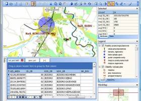
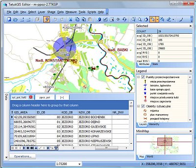
The TatukGIS Editor is a programmable, general purpose desktop GIS mapping and data editing application featuring support for dozens of vector, image, grid, and SQL database formats, on-the-fly map reprojection with nearly 3,000 pre-defined coordinate systems, compatibility with leading database engines, GPS connectivity… For power users with specialized or advanced requirements, a built-in scripting IDE provides the means to customize or extend the product beyond its core features.
The TatukGIS Viewer is a free, slimmed down version of the Editor product, without features for creating/editing data and for customization with scripts. The feature list for the Editor and free Viewer products is presented in the Feature Matrix.
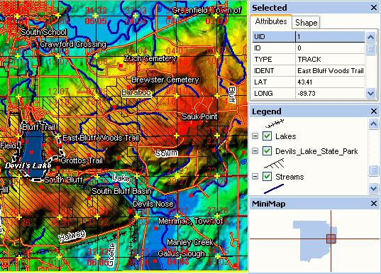
Viewing: The Editor and Viewer open most GIS/CAD vector map files, raster maps, aerial images, grid data, and SQL database layers such as Oracle Spatial, ESRI ArcSDE, or PostGIS coverages. Both products can open TatukGIS projects and most ESRI ArcView v.3 or MapInfo Professional projects and projects exported from ESRI ArcGIS/ArcMap using the free Arc2TatukGIS plug-in. Each data type is supported “natively’, so there is no need to import data into any internal format. Comprehensive visual layer property and legend controls provide for deep customization of the appearance of each map layer, thematic mapping, layer hierarchies, legend presentation, scale… Both products support advanced query and selection features, including SQL Query Builder.
Coordinate systems: The Editor and Viewer support nearly 3,000 pre-defined map coordinate systems in use around the world (including all U.S. State Planes coordinate systems), user-defined coordinate systems based on 120 supported projections, automatic layer coordinate system recognition and on-the-fly conversion of vector and raster layers from multiple coordinate systems for display as a single map. The support reflects EPSG codes and OpenGIS WKT coordinate system definitions. The Editor can export map data to any selected coordinate system.
Editing: The Editor contains features to create, edit, save, and import/export GIS map files and import/export attribute data between vector map layers and external databases. The Editor can be used as a conversion tool to translate map layers between supported file types and/or coordinate systems. Special tools include the topology builder/corrector to systematically clear geometry related errors (overlapping polygons, holes between polygons, missed line intersections, dangling nodes, etc.) from vector line or polygon layers.
Scripting: The Editor is a fully scriptable IDE for writing and debugging code. Using Basic or Pascal scripts, the Editor functionality can be enhanced or modified, including full menu redesign, custom dialog boxes, etc., for end-user custom applications. The scripting engine exposes (inside the Editor) the full power of the TatukGIS Developer Kernel, with its hundreds of classes and thousands of methods, to fulfill the requirements of any kind of GIS application. Dozens of example scripts are provided, e.g., to perform Google or Bing maps integration, GPS tracking on a projected map, batch (command line) conversions between coordinate systems, and various tutorial examples. The special features or customizations can be distributed (deployed) to other Editor licensed users just by sharing the scripts.
Databases: The Editor is compatible with leading database engines, e.g., MSSQL Server, MSJET, Oracle, DB2, Interbase, PostgreSQL and most 3rd party SQL database map layer formats, e.g., Microsoft SQL Server Spatial, Oracle Spatial/Locator, Oracle GeoRaster, ESRI ArcSDE, ESRI ArcSDE Raster, ESRI Personal Geodatabase, MapInfo SpatialWare, Geomedia SQL Server, PostGIS, OpenGIS Simple Features, etc. The Editor supports live joins of vector map layers to external database tables, as well as data import/export with external databases.
The TatukGIS Viewer is a free, slimmed down version of the Editor product, without features for creating/editing data and for customization with scripts. The feature list for the Editor and free Viewer products is presented in the Feature Matrix.
Viewing: The Editor and Viewer open most GIS/CAD vector map files, raster maps, aerial images, grid data, and SQL database layers such as Oracle Spatial, ESRI ArcSDE, or PostGIS coverages. Both products can open TatukGIS projects and most ESRI ArcView v.3 or MapInfo Professional projects and projects exported from ESRI ArcGIS/ArcMap using the free Arc2TatukGIS plug-in. Each data type is supported “natively’, so there is no need to import data into any internal format. Comprehensive visual layer property and legend controls provide for deep customization of the appearance of each map layer, thematic mapping, layer hierarchies, legend presentation, scale… Both products support advanced query and selection features, including SQL Query Builder.
Coordinate systems: The Editor and Viewer support nearly 3,000 pre-defined map coordinate systems in use around the world (including all U.S. State Planes coordinate systems), user-defined coordinate systems based on 120 supported projections, automatic layer coordinate system recognition and on-the-fly conversion of vector and raster layers from multiple coordinate systems for display as a single map. The support reflects EPSG codes and OpenGIS WKT coordinate system definitions. The Editor can export map data to any selected coordinate system.
Editing: The Editor contains features to create, edit, save, and import/export GIS map files and import/export attribute data between vector map layers and external databases. The Editor can be used as a conversion tool to translate map layers between supported file types and/or coordinate systems. Special tools include the topology builder/corrector to systematically clear geometry related errors (overlapping polygons, holes between polygons, missed line intersections, dangling nodes, etc.) from vector line or polygon layers.
Scripting: The Editor is a fully scriptable IDE for writing and debugging code. Using Basic or Pascal scripts, the Editor functionality can be enhanced or modified, including full menu redesign, custom dialog boxes, etc., for end-user custom applications. The scripting engine exposes (inside the Editor) the full power of the TatukGIS Developer Kernel, with its hundreds of classes and thousands of methods, to fulfill the requirements of any kind of GIS application. Dozens of example scripts are provided, e.g., to perform Google or Bing maps integration, GPS tracking on a projected map, batch (command line) conversions between coordinate systems, and various tutorial examples. The special features or customizations can be distributed (deployed) to other Editor licensed users just by sharing the scripts.
Databases: The Editor is compatible with leading database engines, e.g., MSSQL Server, MSJET, Oracle, DB2, Interbase, PostgreSQL and most 3rd party SQL database map layer formats, e.g., Microsoft SQL Server Spatial, Oracle Spatial/Locator, Oracle GeoRaster, ESRI ArcSDE, ESRI ArcSDE Raster, ESRI Personal Geodatabase, MapInfo SpatialWare, Geomedia SQL Server, PostGIS, OpenGIS Simple Features, etc. The Editor supports live joins of vector map layers to external database tables, as well as data import/export with external databases.
TatukGIS Viewer 5.94.0.3539 download tags
TatukGIS Viewer 5.94.0.3539 Windows 7 release notes
New Release
Hotfix:
Fiox dor rong units being used on some comboboxes in the Legend Properties Form in the corresponding DK release.
[ TatukGIS Viewer release history ]
Hotfix:
Fiox dor rong units being used on some comboboxes in the Legend Properties Form in the corresponding DK release.
[ TatukGIS Viewer release history ]
Bookmark TatukGIS Viewer
TatukGIS Viewer for Windows 7 - Copyright information
All TatukGIS Viewer reviews, submitted ratings and written comments become the sole property of Windows 7 download. You acknowledge that you, not windows7download, are responsible for the contents of your submission. However, windows7download reserves the right to remove or refuse to post any submission for any reason.
Windows 7 Download periodically updates pricing and software information of TatukGIS Viewer full version from the publisher, but some information may be out-of-date. You should confirm all information.
Using warez version, crack, warez passwords, patches, serial numbers, registration codes, key generator, pirate key, keymaker or keygen for TatukGIS Viewer license key is illegal and prevent future development of TatukGIS Viewer. Download links are directly from our mirrors or publisher's website, TatukGIS Viewer torrent or shared files from free file sharing and free upload services, including Rapidshare, MegaUpload, YouSendIt, SendSpace, DepositFiles, DivShare, HellShare, HotFile, FileServe or MediaFire, are not used.
Post TatukGIS Viewer review


Windows 7 TatukGIS Viewer related downloads
FastStone Image Viewer is a fast, stable, user-friendly image browser, converter ... a nice array of features that include image viewing, management, comparison, red-eye removal, emailing, resizing, cropping and ...
Graphic Print Manager, is a powerful tool for photo ... as well as the desired resolution and quality. GraphicPrint has filters that ensure the highest quality to ...
WildBit Viewer offers users the ability to view, edit, and design slideshows with their pictures. With ...
Portable AMP Tile Viewer is a handy utiliy desgned to enable you to view your images images as a mosaic, using the ...
Portable AMP Tile Viewer is a handy utiliy desgned to enable you to view your images images as a mosaic, using the ...
My Account
Help
Windows 7 Software Coupons
-
WinX MediaTrans
63% Off -
MacX DVD Ripper Pro
50% Off -
MacX DVD Video Converter
58% Off -
Media Player Morpher
85% Off -
WinX DVD Ripper
50% Off
My Saved Stuff
You have not saved any software.
Click "Save" next to each software.
Click "Save" next to each software.
Would you like to receive announcements of new versions of your software by email or by RSS reader? Register for FREE!
Windows 7 Downloads Picks
- Blender Portable 4.1.1
- Embird 2023 B10.86
- Photo Editing & Saving Wizard 2021
- TatukGIS Viewer 5.94.0.3539
- Diagram Designer 1.29.5
- Portable FastStone Image Viewer 8.2
- RLPlot 1.5
- NVIDIA PhysX 9.23.1019
- packVol Standard 3.8.8
- Portable PicPick 7.4.1
- Adobe Camera Raw 14.4
- ImageMagick for Windows 7.1.1-47
- Abacre Photo Editor 2.1.1
- Adobe SpeedGrade CC
- GT Text 2.0.2
- Spontz Visuals Editor 2.1
- Portable Inkscape 1.4.3
- Photo Stamp Removal 15.1
- Asymptote 2.88
- Albumin 3D 1.7.1
Popular Tags
jpg
plugin
bmp
scanner
pictures
designer
vanderlee
image
tool
images
digital
macromedia
photoshop
adobe
exif
graphics
effects
screen
photo
picture
corel
video
photos
color
filter
jpeg
design
zoom
resize
graphic
Popular Windows 7 Software
- CorelDRAW X7 (x32 bit) 17.4.0.887
- CorelDRAW X7 (x64 bit) 17.4.0.887
- CorelDRAW X5 15.2.0.686
- CorelDRAW X4
- iTop Screenshot 1.2.3.544
- CorelDRAW 2017 19.1.0.419
- CorelDRAW X6 16.4.0.1280
- Blender - 32 bit 2.80
- Adobe InDesign CS5 CS5.5 7.5.3
- CorelDRAW X8 18.0.0.450
- Graphic Workshop Professional 15.0a rev11
- Model Air Design 2.4
- Blender Portable 4.1.1
- Paint.NET 5.0.13
- Model Air Design 2.4
© 2026 Windows7Download.com - All logos, trademarks, art and other creative works are and remain copyright and property of their respective owners. Microsoft Windows is a registered trademarks of Microsoft Corporation. Microsoft Corporation in no way endorses or is affiliated with windows7download.com.